Save this image free of charge
in 800 pixels for layout use
(right click, Save as...)
|
|
Ref : V01550
Theme :
Looking at Earth - Sea - Coast - Capes - Peninsula (601 images)
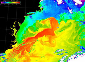
Title : Gulf Stream's Brightness Temperature
Caption :
On May 2, 2001, the Nasa satellite obtained this spectacular image of the Atlantic Ocean's Gulf Stream. The false colors in the image represent 'brightness temperature' observed at the top of the atmosphere. The brightness temperature values represent heat radiation from a combination of the sea surface and overlying moist atmosphere. The red pixels in this image show the warmer areas (approaching 250C), greens are intermediate values (12-130C), and blues are relatively low values (less than 100C). Notice the considerable detail in the swirls and gyres of the current patterns in the Gulf Stream. This image was produced using detectors that are sensitive to the 11-micron wavelength. Brightness temperature is actually a measure of the photons at this wavelength received by the spacecraft, but presented in units of temperature (Celsius). Since the atmospheric water vapor emits photons at this wavelength in addition to those emitted by the underlying sea surface, what you are actually seeing is a combination of both. Thin clouds and water vapor at higher altitudes appear as cooler areas. Heat is being released into the overlying atmosphere from the ocean, raising the humidity. This image depicts the complex interaction of the sea with the atmosphere.
|
|

